Questions & Answers
About the Project
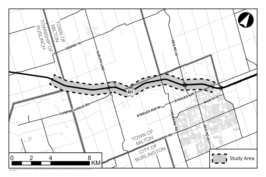
The Project limits along Highway 401 extend from Steeles Avenue in Milton to 1.5 km west of the Halton-Wellington boundary (approximately 17 km), within the Town of Milton (Halton Region) and the Township of Puslinch (Wellington County).
The Study Area includes interchanges and roads and rail crossings over/under Highway 401 within the Project limits and the area required to complete environmental and engineering investigations for the Study.
This Project will follow the approved planning process for a Group ‘B’ project under the MTO Class Environmental Assessment for Provincial Transportation Facilities (amended 2000).
Alternatives will be generated and evaluated based on technical and environmental factors, and in consultation with Indigenous Communities, public, stakeholders, municipalities, and government agencies.
The Project Team will assess environmental impacts and prescribe mitigation measures to be carried forward for the subsequent detail design phase of the Project. Online Public Information Centres will be held during this Study to provide interested parties with the opportunity to discuss the Study and provide input to the Project Team. Upon Study completion, a Transportation Environmental Study Report will be prepared and available for comment.
This Study includes the consideration of potential improvements along the Highway 401 corridor to address both existing and long-term transportation and operational needs within the Study Area. Improvements investigated as part of this Study include highway expansion to provide additional capacity, High Occupancy Vehicle (HOV) lanes, and bridge, illumination, drainage, and interchange modifications.
This Project includes the first Environmental Assessment Study to review operational improvements of the existing Highway 401 from Steeles Avenue in Milton westerly to 1.5 km west of the Halton-Wellington boundary.
The Project is a key component of the broader framework of Ministry of Transportation Class Environmental Assessment studies and projects required to improve the movement of people and goods along the critical Highway 401 corridor through this area.
With the constructed highway expansion to the east and Environmental Assessment approval for expansion of the highway to the west of the Project limits, the Project is reviewing how to address both existing and long-term transportation and operational needs for this Study Area.
Answer: The Project commenced in November of 2023. It is anticipated to continue until Summer 2027. The materials for Public Information Centre 1 were available online for comment from May 29, 2025 to June 25, 2025, with a Live Event held on June 12, 2025. Public Information Centre 2 is tentatively scheduled for Winter 2027. A Transportation Environmental Study Report will be made available for comment at the end of this Study.
The Project Team is currently undertaking a preliminary design and Class Environmental Assessment Study. The timeframe for subsequent design and construction phases is not currently known and is subject to funding and approvals.
The Project’s key objectives are to:
- Address existing operational issues on Highway 401 throughout the Project limits.
- Address future capacity needs of this Highway 401 corridor.
- Minimize the impacts of the Project on the natural, socio-economic, and cultural environments.
Consultation and Engagement
Proponents can visit the Ministry of Transportations Corridor Management website to learn more about the land development review process and to initiate the application process for land development within the Ministry’s Permit Control Area here: https://www.ontario.ca/page/highway-corridor-management.
Consultation and engagement will take place throughout the Project with the public, stakeholders, Indigenous Communities, regulatory agencies, and municipalities.
Two online Public Information Centres are planned for the Project to provide interested parties with the opportunity to discuss the Project and provide input to the Project team. The first Public Information Centre will present the project overview, proposed evaluation criteria, and the generation of alternatives. The second Public Information Centre will present the evaluation of alternatives and the preliminary design Recommended Plan.
Upon Study completion, a Transportation Environmental Study Report will be completed and will outline the Recommended Plan, the potential impacts to the environment, and proposed mitigation measures and commitments for the next phase of design. The Transportation Environmental Study Report will be available for a 30-day comment period.
All notifications for this Project, including Notice of Commencement, Notification of Public Information Centres, and Notice of Study Completion (advertising the availability of the Transportation Environmental Study Report for comment) will be published in the Wellington Advertiser (in print), on Inside Halton (online), and distributed to those on the Project’s contact list. All notices will be made available on the Project website.
Notice of Study Commencement was delivered to the Project’s contact list and advertised in the above papers on November 30, 2023.
Notice of Public Information Centre 1 was delivered to the Project’s contact list and advertised in the above papers on May 22, 2025.
To be notified of future Project milestones join our contact list.
Answer: For up-to-date project information, and to participate in the EA Study, please visit the Project’s website and join the Project’s contact list.
The Project team will consult with staff from Wellington County, the Township of Puslinch, the Town of Milton, and Halton Region as well as regulatory agencies. Consultation will take place at the Project’s key milestones and throughout the preliminary design and Environmental Assessment.
Public Information Centre 1 materials will be posted to the Project website and Comment Forms may be submitted until June 25, 2025. Public Information Centre 1 materials will remain online for reference for the duration of the Project.
Following Public Information Centre 1 we will:
- Respond to comments received during the PIC Comment Period (comment period ends June 25, 2025);
- Use the evaluation criteria to assess and evaluate the alternatives in order to select the preferred alternative;
- Identify preliminary property requirements and environmental impacts of the preferred alternative; and
- Present the preferred alternative at Public Information Centre 2 (tentatively scheduled for Winter 2027).
Note that consultation with Indigenous Communities, the public, stakeholders, municipalities, and government agencies will continue throughout the Study.
For more information, please attend the Public Information Centres. After Public Information Centres are held, the Public Information Centre materials will remain available on the Project website (Consultation – Highway 401 Milton). You can also contact the Project Team anytime at ProjectTeam@Highway401Milton.ca
Permission to Enter
If you have received a Permission to Enter (PTE) letter, the Ministry is requesting to access your property to complete the required fieldwork and / or investigations necessary for the Project. The Ministry is requesting that the “Permission to Enter” form (included with your Permission to Enter Package) be signed by the Property Owner, to permit members of the Project Team to undertake the environmental field surveys and engineering investigations necessary to support the Preliminary Design Class EA Study. Fieldwork is a vital part of the study, and the data collected supports the Project with identifying existing environmental conditions and informs decisions on all aspects of the Project.
The Ministry’s request to access your property does not mean your property is directly affected by the project or that it will be acquired. Direct property impacts will be determined during future phases of the Project once the alternative improvements to the highway have been assessed and a preferred approach to addressing existing and future transportation and operational needs has been identified.
Access to your property may be required on one or more occasions throughout the Study, which is anticipated to be completed by Summer 2027. The Ministry recognizes the sensitivity of this request for access and will work with Property Owners to schedule fieldwork and provide advance notice of the planned investigations via phone call or email. Please review the form, retain a copy for your files and return a signed copy back to the Project Team. If you have any questions about the proposed fieldwork or require assistance in completing the form, please contact us.
Many types of fieldwork are required for this Preliminary Design and Class EA Study ranging from visual surveys to subsurface investigations completed with large equipment. By signing and submitting the PTE form you are providing the Project Team access your property to complete Category A, B, and / or C levels of investigations:
Category A – Visual Observations.
Category B – Investigations which may require small test holes dug by hand or ploughing of agricultural fields.
Category C – Subsurface investigations and potential access by large equipment.
Category A – Visual Observations may include the collection of field data and existing conditions through environmental and engineering surveys, photographs, mapping, or similar activities. This work may include:
- Environmental Investigations by natural resource (e.g., fisheries, wildlife, wetland, vegetation), groundwater, drainage, land use, contamination, waste management, agricultural, archaeology, and / or cultural heritage specialists.
- Engineering Investigations such as engineering topographic surveys.
Category B – Investigations may require small test holes dug by hand or ploughing of agricultural fields to uncover potential archaeological significant objects or similar activities. This work may involve members of the Project Team digging small holes on your property to observe archaeological resources, or for the purposes of engineering studies required for the Project.
For properties that are identified for Stage 2 Archaeological Assessments, the assessment methods will include either pedestrian surveys of agricultural fields or subsurface shovel testing for other areas that are not heavily disturbed.
Shovel testing and / or test pitting includes digging small hand excavation tests pits within lawns or forested areas. All test pits will be 30 cm x 30 cm in size and excavated at least 5 cm into sub-soil. All material from each unit will be screened for artifacts and then all units will be back-filled and recapped to grade. Affected areas will be restored to existing condition upon completion of the survey.
Pedestrian surveys involve a team walking across the property and/or recently ploughed and weathered fields to visually inspect the soil for archaeological resources or artifacts. If artifacts are located, the team will collect a sample for submission to the Ontario Ministry of Citizenship and Multiculturalism.
All archaeological field investigations conducted on your property will be completed in accordance with the Ontario Ministry of Citizenship and Multiculturalism Standards and Guidelines for Consultant Archaeologists. In addition, ploughing of agricultural fields prior to archaeological assessment will only be undertaken with consideration of crop status and in coordination with the Property Owner.
Photos showing Stage 2 archaeological assessments (test pitting and pedestrian survey of an agricultural field) are shown below:
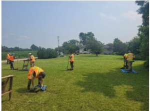 Test Pitting (AECOM, 2023)
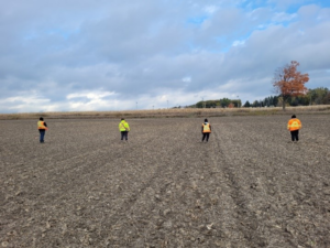 Pedestrian Surveys (AECOM, 2023)
Category C Investigations are subsurface investigations that may include hand or machine dug holes or boreholes to confirm location of utilities or to collect soil and or groundwater samples. Some subsurface investigations do require access by large equipment (i.e., portable truck or track mounted drill rig, agricultural equipment, vacuum excavator, backhoe or other similar equipment) for soil data collection, test pits to document underground utilities, or similar activities.
Only some properties need geotechnical and groundwater investigations. Any disturbance to lands due to machine access or field investigations will be reinstated to existing conditions following the completion of field work.
When required, the equipment is transferred from the closest accessible road and / or driveway to the borehole site. Tree and shrub removal is sometimes required for access to the drilling site. Vegetation removal on private property will be avoided unless specifically discussed and agreed upon in advance with the Property Owner.
Boreholes (completed with a drill rig, like those pictured below) are a hole (a few inches in diameter) drilled into the ground to collect soil samples. Sometimes a monitoring well is installed within a borehole to collect samples and monitor seasonal variations of groundwater. Should a monitoring well require installation on your property the Project Team will inform you ahead of time. The monitoring well is a steel casing, a few inches in diameter to fit within the borehole and approximately 6 inches tall. The Ministry of Transportation will decommission the monitoring well once the necessary information is collected for the Highway improvements. All affected areas will be restored to existing condition upon completion of the investigation.
Photos of the type of equipment that may be used for borehole drilling work on your property are below:
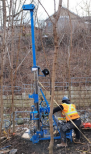 Portable drill rig (AECOM, 2023)
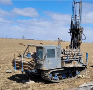 Track carrier mounted drill rig (AECOM, 2023)
Field Studies / Impact Assessment
Field and desktop investigations for disciplines such as geotechnical, natural sciences (fisheries and terrestrial), archaeology, cultural heritage, noise, contaminated property and waste management, groundwater, land use, landscape composition, erosion and sediment control, snow drift, air quality, drainage, etc. will be completed to collect background / existing conditions information.
These environmental investigations are ongoing. Following these investigations and completion of the recommended preliminary design plan, the Project team will determine potential environmental impacts and develop mitigation measures to avoid or minimize potential impacts as best as possible.
The results of these investigations and the proposed environmental mitigation and protection strategies will be documented in applicable study reports and summarized in the final TESR.
The following environmental studies will be completed within the Study Area as part of this Study:
- Fish and Fish Habitat
- Terrestrial Ecosystems
- Noise Assessment
- Land Use/Designated Areas
- Agricultural Assessment
- Built Heritage and Cultural Heritage Landscapes
- Archaeology
- Air Quality
- Groundwater
- Surface Water
- Contaminated Properties and Waste Management
- Landscape Composition
- Snow Drift
- Erosion and Sediment Control
Results of these studies will be summarized in a Transportation Environmental Study Report, which will document the design and environmental process, and potential environmental impacts and mitigation measures. The Transportation Environmental Study Report will be made available for comment at the end of this study.
Yes, the Project Team will be undertaking a noise assessment study (as per the Ministry of Transportation’s Noise Guide, 2022) to determine potential traffic noise impacts of the proposed highway improvements within the Study Area. The noise assessment study will determine predicted future noise levels with and without the improvements in place. These future noise levels will be used to determine locations where potential noise mitigation (such as noise barriers) needs to be reviewed for technical, economic, and administrative feasibility within the Study Area.
Following Public Information Centre 1, the Project Team will select a preferred alternative design that will be used to complete a preliminary Impact Assessment of the Project. The preliminary Impact Assessment, including the results of the noise assessment, will be shared as part of Public Information Centre 2. The final Impact Assessment results will be summarized in the final Transportation Environmental Study Report, which will be available for public comment at the end of this Study.
The Ministry of Transportation recognizes the impacts that construction-related noise can have on communities. The impacts and mitigation of construction noise will be reviewed in a subsequent design phase.
Yes, this Project will identify illumination requirements within its limits. In developing the lighting design, mitigation measures to minimize light trespass will be identified (e.g., location, pole height, shielding of luminaires, etc.).
The Environmental Assessment requires the Project Team to complete many types of desktop and field investigations to confirm the existing conditions of the Study Area in order to accurately identify the potential impacts of the Project on the environment and identify necessary commitments for further consideration in the next stages of the Project. As part of this Environmental Assessment at the Preliminary Design stage of the Project we have completed or will be completing the following ecological desktop and field investigations: fish habitat assessments, breeding bird surveys, nocturnal amphibian surveys, screening for Significant Wildlife Habitat and Species at Risk, preliminary habitat assessment, and Ecological Land Classification study to identify significant environmental features and candidate habitat for Species at Risk and Species of Conservation Concern.
The preliminary results of desktop analysis are shared in the Public Information Centre 1 materials and the final results of field investigations will also be summarized in the Transportation Environmental Study Report which will be available for public comment at the conclusion of the Study.
The Project Team is undertaking a review of the terrestrial and aquatic ecosystems and is in the process of confirming the existing environmental conditions within the Study Area. The Project Team has identified a number of environmentally sensitive features within the Study Area including but not limited to multiple watercourses, Significant Wildlife Habitat for birds, Guelph Junction Wetland Complex, and Mountsberg Reservoir Marsh. Impacts to these features will be considered in the assessment of alternatives. An assessment of design alternatives based on the Project’s evaluation criteria will be used to select the preferred alternative which, following Public Information Centre 1, will be developed into the Recommended Plan. Once the Recommended Plan is developed, the Project Team will complete an Impact Assessment to identify environmental impacts that cannot be avoided. These impacts will be addressed with proposed environmental protection and mitigation measures that will be considered and applied, where practical, during subsequent design and construction phases.
Preliminary Impact Assessment results will be shared at Public Information Centre 2 and summarized in the Transportation Environmental Study Report. Environmental Commitments for the next phase of design and construction and the proposed mitigation measures to address potential impacts to environmentally sensitive features will also be shared in the Transportation Environmental Study Report.
A Cultural Heritage assessment is currently being undertaken that will identify properties of known or potential cultural heritage value. Properties that have been identified to date as having known cultural heritage value can be found in the Public Information Centre 1 presentation materials. Country Heritage Park is an example of a known cultural heritage site within the Study Area that showcases agriculture and rural life from the past 150 years.
The Cultural Heritage assessment will be summarized in a Cultural Heritage Existing Conditions and Preliminary Impact Assessment Report. The research and evaluation of known, or potential, built heritage and cultural heritage landscapes identified in the Cultural Heritage Existing Conditions and Preliminary Impact Assessment Report as requiring assessment, will be documented in a Cultural Heritage Evaluation Report (CHER) and Heritage Impact Assessments (HIA).
The Project Team is also completing Stage 1 and Stage 2 Archaeological Assessments as per the requirements of the Standards and Guidelines for Consultant Archeologists in accordance with the Ontario Heritage Act. These field investigations will identify areas of archeological potential and cultural significance within the Study Area and will be completed in consultation with, and with participation from, Indigenous Communities.
The Project Team has completed Fish and Fish Habitat field investigations to characterize the fish habitat within the Study Area. Many watercourses with the potential to support fish exist within the Project limits including watercourses known to provide habitat to Species at Risk. Impacts to watercourses, fish, and fish habitat will be considered in the assessment of design alternatives based on the Project's evaluation criteria and will be used to select the preferred alternative. The need for watercourse modifications such as realignment will be identified following the development of the Recommended Plan.
Where potential impacts to Species at Risk are identified, the Ministry of Transportation will work with regulatory agencies to meet the regulatory requirements.
Once the evaluation of alternatives is complete and the Recommended Plan is developed the Project Team will undertake a local air quality assessment and greenhouse gas emissions impact assessment of the Recommended Plan as per the Ontario Ministry of Transportation’s Environmental Guide for Assessing and Mitigating the Air Quality Impacts and Greenhouse Gas Emissions of Provincial Transportation Projects (May 2020). This assessment is a desktop study that assesses the predicted air quality for the Study Area in two modeled scenarios: the predicated future air quality without improvements and the future predicted scenario with the improvements constructed. The results of this assessment will be summarized in the final Transportation Environmental Study Report, which will be available for public comment at the end of this Study. Air Quality impacts resulting from construction will be reviewed in the next stages of the Project as construction methods and staging are further considered.
The Project Team acknowledges the public’s concerns about climate change. The need for highway improvements is highlighted by the Greater Golden Horseshoe (GGH) population and employment growth forecasts. By 2051, the population of the GGH is expected to grow to 14.8 million people, and unmanaged growth can have negative impacts on the region’s air quality, water resources, and natural heritage resources. Improvements to the existing highway network is key for the safe and efficient movement of goods and people, and to reduce greenhouse gas emissions and other negative environmental impacts.
Once the evaluation of alternatives is complete and the Recommended Plan is developed the Project Team will undertake a local air quality assessment and greenhouse gas emissions impact assessment of the Recommended Plan as per the Ontario Ministry of Transportation’s Environmental Guide for Assessing and Mitigating the Air Quality Impacts and Greenhouse Gas Emissions of Provincial Transportation Projects (May 2020), the results of which will be summarized in the Transportation Environmental Study Report.
Once the Recommended Plan is selected the Project Team will assess the snow-drift potential considering wind speed and direction, snowfall depths, and topography along the highway. The Project Team will also consider the application of mitigation, such as landscaping and natural vegetation, as snow drift barriers are to be reviewed in later stages of design. The results of the assessment will be summarized in the Transportation Environmental Study Report.
The Project Area lies within lands designated under the Greenbelt Plan (2017) and some of the proposed alternatives result in non-agricultural uses to lands presently used for agricultural purposes. For this reason, the Environmental Assessment Study must include an Agricultural Impact Assessment (AIA). The AIA is a study that evaluates the potential impacts of non-agricultural development on agricultural operations and the agricultural system and recommends ways to avoid or, if avoidance is not possible, minimize and mitigate adverse impacts. The results of the AIA will be used to assess the alternatives and impacts of the Recommended Plan will be summarized in the Transportation Environmental Study Report.
In alignment with Ontario Regulation 406/19: On-Site and Excess Soil Management, as the Project Team reviews the alternatives we consider the effect of each alternative on the soils within the Project site, including the potential to produce excess soil that requires transportation off site at the time of construction, as well as management of soils with potential for contamination. This work includes preliminary calculations of excess soil volume and development of a preliminary Earth Management Plan as well as a desktop investigation and windshield level survey of present land uses and reported incidents (i.e. spills) that identify areas of potential contamination. These reports provide recommendations for next steps to be taken in later stages of the Project and inform subsequent stages of design.
At this stage of the Project the Project Team will complete a Hydrogeological Assessment of the Study Area. This assessment involves the review of technical documents including past watershed studies, groundwater database reports and source water protection assessments. This preliminary assessment identifies the potential impacts to groundwater as a result of the implementation of the recommended plan and will prescribe mitigation measures and commitments to future groundwater studies to be carried forward for the subsequent detail design phase of the Project. The results of this assessment will be summarized in the final Transportation Environmental Study Report, which will be available for public comment at the end of this Study.
The existing Highway 401 corridor and right-of-way crosses the Greenbelt lands, including the Niagara Escarpment lands. Impacts to the Niagara Escarpment designated lands and the Niagara Escarpment Planning and Development Act will be considered during the assessment of alternatives and shared at Public Information Centre 2. As the Study progresses, the Project Team will discuss potential impacts and avoidance and protection measures with the Niagara Escarpment Commission, the government agency responsible for administering the Niagara Escarpment Plan.
Both the Greenbelt Plan and Niagara Escarpment Plan support important transportation infrastructure improvements that duly consider environmental impacts and are necessary to the public interest for the movement of people and goods in support of the objectives of the Provincial Growth Plan.
Aligned with Metrolinx’s 2041 Regional Transportation Plan, the High Occupancy Vehicle lanes being considered on Highway 401 within the Study Area are anticipated to facilitate faster and more reliable bus service. High Occupancy Vehicle lanes can support GO Bus route 25 Waterloo/Mississauga, GO Bus route 29 Guelph/Mississauga, and proposed frequent regional express bus routes and services that will serve long-distance transit markets not currently well-served by GO’s proposed Regional Express Rail routes. Adjacent to the Highway 401 corridor, Metrolinx is also undertaking improvement projects for the Kitchener and Milton GO Lines. Metrolinx’s current plans, projects, and programs can be found here: https://www.metrolinx.com/en/projects-and-programs.
The Ministry of Transportation will continue to consult and work with Metrolinx (an agency of the Government of Ontario reporting through the Ministry of Transportation), municipalities, and transit providers to support transit services on highways and/or adjacent local infrastructure to meet overall regional transportation network needs.
The Ministry of Transportation will consult and coordinate with municipalities to investigate and appropriately accommodate existing and proposed active transportation infrastructure within the Study Area. Municipal transportation plans that will be considered during the Project include the:
- 2024 Town of Milton Transportation Master Plan Update;
- 2023 Township of Puslinch Roads Management Plan;
- 2022 Wellington County Road Master Action Plan; and,
- Fall 2025 (Anticipated completion) Halton Region Integrated Master Plan. (For more information on the Halton Region study, including their public information centre 2, please see: https://www.halton.ca/For-Residents/Opportunities-to-Participate/Water-Wastewater-Transportation-IMP.)
Other active transportation facilities that will be considered during the study include the Province wide cycling network developed as part of Ontario’s Cycling Strategy and the Bruce Trail.
The traffic study includes an operational performance review, which will identify safety improvements within the Project limits. This study reviews relevant background information, such as historical traffic and collision data and existing highway geometry, and also includes a field review of existing conditions and roadside safety.
Potential safety and operational improvements and other measures to address any identified safety concerns and risks will be considered during this Study and in subsequent phases of design and construction.
Potential impacts to the Bruce Trail have not been determined at this point. Potential impacts to the Bruce Trail will be considered during the evaluation of alternatives and the Project Team will continue to consult with Bruce Trail Conservancy throughout the study.
The Project Team will include commitments, for subsequent phases of design and construction, in the Project’s Transportation Environmental Study Report to continue consultation with Bruce Trail Conservancy to address construction staging and mitigate potential impacts to the trail or trail users during construction.
The Project Team recognizes that maintaining transportation network connectivity during construction is important. Minimization of potential impacts to traffic operations during construction and construction staging are key factors that will be considered during the evaluation of alternatives and development of the Recommended Plan. Preliminary construction staging will be documented in the Transportation Environmental Study Report for this Project and details will be further developed during subsequent design stages. Elements of construction staging design may include public/stakeholder notifications, temporary lane closures, traffic control, roadway protection systems, and temporary detours.